
Few things are more uncomfortable than dirt trapped in a pair of wool socks. This is never more apparent than when hiking. This dirt, allied with small pebbles, somehow infiltrates the "impermeable" socks just purchased as Sports Basement and gives the slip to the "rock guard" on the brand new boots that guaranteed no rocks shall pass. It then proceeds, unchecked, past the ankle, the bridge, and the arch, and somehow manages, like an unstoppable rebel force, to embed itself in between each toe. A strange cause and effect happens here, it seems dirt scrapping between the big toe and the second triggers the mouth to fire off strings of expletives– who knew?
Adding to the irritation, a fair amount of dampness accumulates throughout the foot and a hundred torturing burs stick through the pair of calf-high pulled up wool socks and prick the pale skin that has other wise been hiding under jeans and khakis for the last six months. After a full day of walking, seemingly all uphill, one can only wonder why hiking is said to be therapeutic. This is why I recommend a different approach to finding gorgeous views and picturesque landscapes: just drive there. The Panoramic Highway, off of Highway 101 north of San Francisco will take you all the way to the top of one of the Bay Area’s finest lookouts, Mt. Tamalpais.
Loaded into a Subaru, my party starts the journey to Mt. Tam heading over the Golden Gate bridge from the University of San Francisco. I ride shotgun, dad is the behind the wheel, and mom is behind us. The first order of business is food. Mom, wearing a USF supporting green sweater with blonde hair fluttering in the rolled down window, yells from the back seat, "Where do you want to stop for food?" Dad decides quickly on fish and chips in Sausalito. Pulling off the highway to Sausalito and up into neighborhood parking, Dad, sporting Wranglers and a very fitting pair of boat shoes, leads us down to the marina. Down near the docks, large crowds swarm the brightly colored tourist shops that promise Bay Area treasures and artwork, offer cheap SF trinkets, and will even sell an Alcatraz t-shirt for $8.99, or three for $14.99– I still don’t know how that works. Everything here is stereotypical– the Asians take pictures, the Eastern Europeans and Russians yell at their kids, and an Italian grandma can’t stop sobbing about something someone did– so we continue on to a less populated spot.
Here we find the Cat n’ Fiddle. This restaurant slash bar offers seafood, steaks, and sandwiches with all the trimmings. Mom orders the Halibut fish and chips, Dad has the corn beef sandwich– he doesn’t recommend it– and I go with the basic burger. All and all, it’s a decent meal, and with a few pints of ale the barely par performance from the Cat n’ Fiddle is barely noticed. Over next hour we let our stomachs digest and then its time to hit the road again.
Speeding down on Highway 101 for a short while we turn off on the well marked Mt. Tamalpais exit and head through Mill Vally, past the famous Proof Lab surf shop and left onto Panoramic Highway. Let the curves begin.
Winding through neighborhoods clumped between coastal redwoods and ferns, the Subaru ramps up rpms, cresting steep hills only to dip down once again. Soon, the Stinson Beach exit sign approaches– stay right for the mountain, detour left for a beach romp. Veering right, up further through the woods, to the summit and a rock star view of San Francisco we go. A lesson is learned here– excessive turns, however necessary, cause car sickness on a still full stomach. My advice is to pull over a few miles up the road at the Muir Woods turnoff to let the nausea subside as well as to enjoy the view of plush forests engulfing the valley below.
Back in the car, taking turns again, the pinnacle of Tamalpais looms ten miles in the distance. From here, the air becomes thinner, ears begin to pop, and the road’s grade reaches increasing heights. We will eventually reach 2,571 feet elevation. Nine miles more and a curious leveling of the road occurs. Don’t be fooled, this is not the top. A steep decent followed by a hulking accent, ending in a five dollar parking lot, marks the crown of Mt. Tam. The view from the lot is gold.
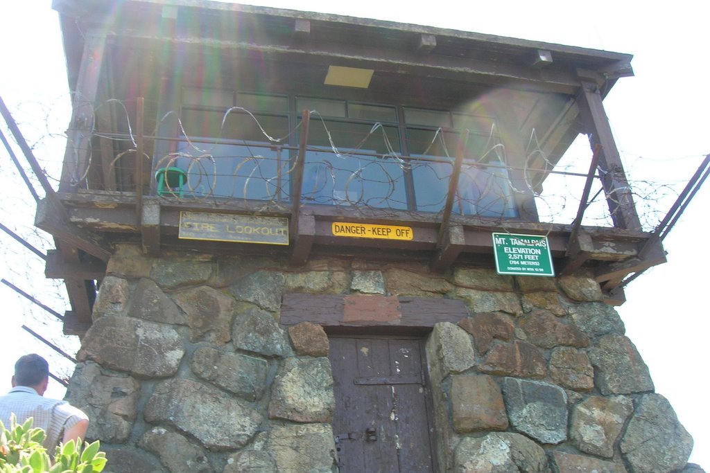
Once the location of "The Crookedest Railroad in the world," the Mt. Tamalpais of old offered passengers in the early 1900's a trip to the top and a 10 mph free fall down of which gravity was the only driving force, according to the trail head’s information post. John McKinney of thetrailmaster.com said the rail had 281 curves each way, but a wildfire knocked this thrill ride out of commission. Now, equally crooked roads and trails climb to the top, giving bikers a grueling pedal, hikers a painstaking walk, and drivers a windy course on which to test their stomachs. At the top, Mt. Tam has a small ranger station that offers trail maps and guides as well as a snacks for slightly exorbitant prices. The parking lot lies about a quarter of a mile from the high point where a rocky switch back trail makes its way up the rest.
The unbeaten path, riddled with jagged yellow shale rock, limits the speed of the accent. Parents with young children beware, the little ones will have a hard time reaching the top. Peaking out from behind the last corner of the trip, an old barbed wire covered ranger station is perched on the highest part of the peak, called the Gardner Lookout. This daunting site is Tamalpais’ welcoming gesture– it shows guests the attitude Tamalpais once had. The memorial plaque on the station said it was constructed in 1937 dedicated to Mount Tamalpais Fire Chief Edwin Borroughs Gardner. Gardner, the fire chief from 1917–1935, died in 1935, after living through the crooked railroad fire of 1930 just five years prior.
Beyond this beacon of the past lies the lookout point, a rock formation wounded with the stabs of time. Cracks and holes, caused from lightning and erosion, plague the boulder outcropping and make standing on it seem a bit unsafe. However, any uncertainty fades with the southern view. The first recognizable sights are the Golden Gate Bridge, the Marin Headlands, the towns of Sausalito and Marin. Across the bay and past Alcatraz we have our fist encounter with the wonders of SF, the stretching marina. Scanning the city we admire the great Transamerica Pyramid, the green rectangle of Golden Gate park, and the circular spires of Saint Ignatius. Up here, a person can pretend he is God.
On the way back down, a cyclist flies by our car, but we both pass hikers who’s knees surely ache. Looking out the window at blurred trees, the thought of creeping down this coastal mountain in an open box car moving at 10 mph sounds nice. But drivers shouldn’t complain, so I keep my mouth shut.
1 comment:
Nice pix. See comments on hard copy of story and then submit to somewhere in Oregon under the label -- I keep changing my mind on this one -- Letters from College.
Post a Comment